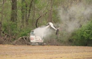
Work to strengthen local levees under way
Levees are largely ignored or forgotten if you don’t live or work in the bottoms close by the Mississippi River.
If they are noticed by most, it is as they cross bridges between Illinois and Missouri, if at all. They also appear in the news during high water or flood events.
For others, they are matters of passion and urgency. One such person is Prairie Du Pont levee commission president Mike Sullivan, who took the Republic-Times out recently to see firsthand what his levee district and the neighboring Fish Lake district are doing to strengthen the levees. The two levee districts stretch about 14.5 miles, from southern St. Clair County into Monroe County and up to the Jefferson Barracks Bridge and Interstate 255. Work being done there is projected to cost $20 million.
The work is important for two reasons.
First, the levees have been weakened by past floods – most recently June 4, when the Mississippi River climbed above 40 feet on the St. Louis gage for only the fourth time since records started being kept in 1861.
Mike SullivanSecond, factors such as underseepage and other subterranean issues have caused the Federal Emergency Management Agency to threaten to withdraw National Flood Insurance Program coverage from properties behind the levees for 74 miles along the Illinois shoreline. This would have devastating impacts on property owners who would lose this insurance, possibly followed by banks calling loans.
To be accredited by FEMA, the levees must be inspected and certified by the U.S. Army Corps of Engineers as being capable of safely warding off a 100-year flood event. That certification measures both levee height and strength.
The levees are actually physically high enough at 52 feet to protect against a 500-year event — one that has a two-tenths of one percent likelihood in any one year.
Sullivan said money being committed is all local funding from the quarter percent sales tax Madison, St. Clair and Monroe counties agreed to self-levy — to pay for levee repairs and upgrades when the federal government proved unable to fund this work.
The levees are federal levees by law, but Sullivan said, “They have decided they don’t protect enough value to pay for their repairs. But we have lived and worked behind them for decades. We don’t agree. So we are funding this work ourselves.”
During the tour, the most visible work seen was acres of soil berms on 80 acres of farm land acquired from six farm families. This work calls for some 350,000 cubic yards – 35,000 dump truck loads – of a sand-soil mixture to be placed in layers on the land. Its weight will then press down to slow underseepage of water flowing under the levees during high water or flood events.
Underseepage can, if left unchallenged, damage or even destroy levees. It is caused by increased hydrostatic pressure from high water on one side of the levee. If it progresses far enough, in addition to water moving under a levee, it can start to pull particles of soil with it, creating a phenomena called sand boiling.
Sand boiling appears first as small cones or boils of bubbling sand in fields. The event can grow if unchecked, and can eventually cause foundation failures that may result in a levee collapse.
Sullivan also pointed out relief wells throughout the protected side of the levee. These are a series of covered corrugated pipes, about two feet in diameter, that stick above ground. They house pipes that reach far underground, to the levels where underseepage flows. They allow the water to bubble to the surface, where it can be held in ponds or pumped over the levee back into the river.
“As we raise the ground level with the berms, we will have to increase the height of these wells to keep them above the ground,” Sullivan said.
The work being performed will also include drilling many new relief wells.
“Some of the new ones will be connected by pipes to new pump stations,” Sullivan said. “We are adding two new pump stations – one in the Prairie Du Pont Drainage and Sanitation District and a second one in the Fish Lake District. They won’t look like the older stations that were buildings on or alongside levees. Instead, they will be in underground concrete casements with only their control panels above ground.”
In addition to the berms, added and improved relief wells and new pump stations, Sullivan said existing relief wells have being cleaned out and refurbished and gravity drain gates are being replaced and upgraded.
Gravity drains release water through levees from inland as it runs toward the Mississippi River. Water flows down the bluffs and across land in the bottoms. It runs to low spots and creeks or drainage ditches there.
Under normal or low river conditions, it is allowed to flow into the Mississippi via what amount to storm sewers. But when the river rises, these paths must be closed by large steel gates. Water runs downhill – whichever direction that may be.
“Once the gates are closed, we can only collect it, or if the run-off and water captured by the relief wells accumulates enough, we have to pump it over the levee,” Sullivan said.
Sullivan’s passion for the levee is a family tradition.
“My father walked these levees, watching for failures in the 1973 flood,” he reminisced. “I joined the district in 1986 and remember well the Flood of 1993.”
Apparently that historic event didn’t deter Sullivan, as he assumed presidency of the Prairie Du Pont District in 1996 and has served as such ever since.
It has to be passion and determination, not money, that drives he and his colleagues. They are paid $78 per month, and they can be see inspecting these levees at any time of the day or night, 365 days a year.
Why should others who don’t live or work in the areas protected by the levees care?
Thousands of Illinoisans cross the bridges spanning the Mississippi River every day. Many work in Missouri. Others shop there or may have medical or other necessities met there. They also go to sporting and entertainment events there.
The failure of these levees might interrupt commerce. While the modern bridges would most likely withstand floods, approach roads might go under water.
This happened, for example, in 1903, when there were no levees. For weeks, the only way to cross between Illinois and Missouri was by boat.
In addition, many communities get water supplies and discharge treated waste via facilities in the river bottom today. Furthermore, countless pipelines and communications and data conduits pass through these same areas and could be lost in major floods that might damage or destroy levees.
So everyone is in fact, dependent on the strength and stability of the levees. Like it or not, we’re all in this project together. We pay for it when we shop in the three counties, and we all benefit from the levees every day.
Right now, two levee districts serving this area are doing something about it.


