Legislative districts change

The Illinois General Assembly passed new state legislative district maps on Friday that change the House and Senate districts in which Monroe county resides, though the changes are not as substantial as previously proposed.
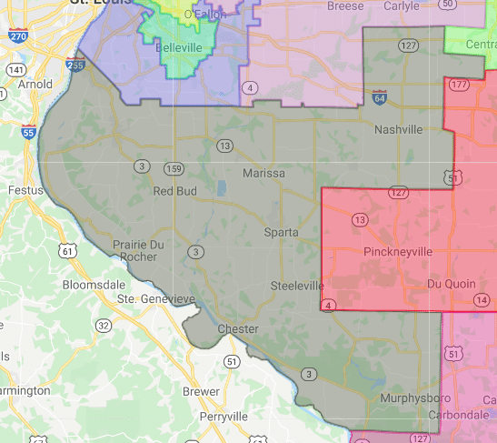
The new maps, which passed the Illinois House and Senate without any Republican support, would renumber the House district from the 116th to 115th district and expand its boundaries to include all of Monroe and Randolph counties and part of Jackson and Washington counties.
The district currently includes all of Monroe and Randolph counties, the southern portion of St. Clair County and the western part of Perry County.
A previous version of the map could have pitted state Rep. Charles Meier (R-Okawville) against state Rep. David Friess (R-Red Bud) because Okawville would have been in the new 115th, but the final version of the map removed Okawville from this district.
Still, Friess said the new maps and the process with which they were drawn “perpetuates public mistrust.”
“After promising for months about having an ‘open and transparent’ process, the Democrats chose to hide behind their locked door,” Friess wrote in his newsletter after voting against the new maps. “They drew the maps in secret and let their members come and choose their voters. What they released was a gerrymandered mess that sought to pit Republicans against each other while allowing current Democrat members the safety of their own district. It made a mockery of the democratic process.”
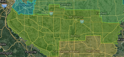
The 58th Senate District, which includes Monroe County, was also changed as part of the new maps, but not in as significant of a manner.

The district’s boundary would be moved northward and eastward. It now stretches from Monroe County east to the Indiana border and from Posey south to near Murphysboro.
Previously, the district only went as far east as Jefferson County and dipped into Union County to the south.
The approved maps were changed slightly from ones introduced about a week earlier, though none of the changes directly affect Monroe County residents.
The Legislature OK’d the maps less than 24 hours after they were introduced, which further raised the ire of Republicans who have been decrying a lack of transparency and faulty data in this contentious partisan process.
“The people of Illinois deserve better than this,” state Sen. Sue Rezin (R-Morris) said. “They deserve better than the bad data, fake deadlines and sham hearings. They deserve the chance to pick their politicians, instead of once again letting politicians pick their voters.”
Various activist groups, including some normally sympathetic to Democrats, voiced many of the same concerns.
Democrats said their conservative colleagues were simply upset because they want to regain control of the House and Senate and their inability to influence the mapmaking process makes that more difficult.
The constitution requires the Legislature to produce a map by June 30. If it fails to do so, an eight-member bipartisan commission that usually deadlocks takes over. Finally the name of a ninth partisan tie-breaker is drawn from a hat so that group can produce maps by Oct. 5.
Democrats also argued the maps, which used the Census Bureau’s American Community Survey data instead of Census data after that decennial study was delayed, are fair and responsive to public input.
“After 50 public hearings across the state and listening to hours of testimony, the House and Senate Democrats have put together a product our state can be proud of,” Rep. Elizabeth Hernandez, chair of the House Redistricting Committee, said in a press release. “What should stand out about this proposed map is how similar districts look compared to our current map.”
For the first time since the 1960s, lawmakers also edited the Illinois Supreme Court district boundaries, but the only changes were in north-central Illinois.
The state has not released a new map for congressional districts after Illinois learned it would lose a seat in the U.S. House of Representatives.


